You're here: Data Management > Internationa Data Managment of GEOTRACES
updated on 27 Jan. 2020
Data Management
International Data Management of GEOTRACES
Design and lunch of the data management system of GEOTRACES was discussed at a data management meeting of GEOTRACES in Liverpool, UK on 30 Nov. - 2 Dec 2005, and a proposal for Data Management in GEOTRACES was developed by the meeting and it has been accepted by GEOTRACES SSC. Full report of the proposal is available in PDF file (188KB).
The following is outline of the proposal.
Structure of Data Management
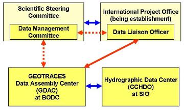
The proposed GEOTRACES Data Management System includes a Data Management Committee, a Data Liaison Officer in the GEOTRACES International Project Office (IPO), and two International Data Assembly Centres (DACs), as shown in the diagram.
Data Management Committee (DMC)
Data Management Committee (DMC) is comprised of data originators, data managers, and data users.
Terms of reference of DMC are to:
- Oversee the work of the GEOTRACES Data Assembly Centres (DACs) and the Data Liaison Officer in the GEOTRACES International Project Office.
- Ensure that GEOTRACES creates and maintains an integrated, international data and cruise inventory
- Oversee the compilation of data from individual principal investigators (PIs) and national projects into a long-term, integrated data set that is submitted to an appropriate data archive and may be published in a suitable format.
- Ensure that GEOTRACES data are available for project scientific purposes and that data management meets the present scientific needs of the project without compromising future needs
- Monitor international acceptance of, compliance with, and adoption of GEOTRACES data policies
- Address the involvement in project data exchange activities of scientists without access to effective data management infrastructure
- Report regularly to and advise the GEOTRACES Scientific Steering Committee (SSC)
Accepting the proposal, a standing committee on Data Management has been established.
Data Liaison Officer (DLO)
Metadata comprised of the essential information about how, what, where, when and by whom data were produced is important information not only for data management but also for project management and coordination. The metadata of GEOTRACES will be managed by Data Liaison Officer working at IPO.
The metadata is temporary managed by the International Data Assembly Centre at present, because IPO is being establishment now.
International Data Assembly Centres (GDAC)
The proposal recommended that GEOTRACES should work with one of the Earth sciences data centres to develop a GEOTRACES data portal, providing integrated access to GEOTRACES data through the Internet.
An International Data Management Centre has been opened at British Oceanographic Data Centre(BODC), Liverpool, United Kingdom since 2007, following the decision of the SSC.
The proposal also recommended to make use of CLIVAR and Carbon Hydrographic Data Office (CCHDO), Scripps Institution of Oceanography, USA, which is already funded to take in profile data internationally, for water column data compatible with the CLIVAR hydrographic data types.
Data Policies
The followings are data policies of GEOTRACES which was amended by the DMC meeting, Washington D.C., USA, 7 November 2009:
GEOTRACES seeks, on the one hand, protection of the intellectual effort and time of originating investigators (those who plan an experiment, collect, calibrate, and process a data set to answer some questions about the ocean), and on the other hand, the need to compare various data sets and data types to check their consistency, to better understand the ocean processes involved, and to see how well the numerical models describe the real ocean.
We stress that data will not be released within the proprietary period (see below) without the permission of the originator.
Data/Metadata Submission (timeline):
- As soon as a cruise is organised:
- Precruise metadata to be submitted to GEOTRACES IPO and GDAC.
- Within one week of cruise completion:
- Submit Postcruise metadata forms from chief scientist
- Submit electronic versions (scanned or original) of event log and log sheets
- Submit copy of ROSCOP/CSR form where one is required by ship operator
- Within 6 months of end of cruise:
- Chief scientist submits cruise report , where one is required by ship operator
- Data and metadata for shared ancillary parameters (e.g., nutrients) submitted to DAC*
- Submit CTD and underway data (both raw and processed files; sensor information and calibration) to national DAC (e.g., BCO-DMO) and BODC.
- As soon as possible, and no more than 2 years:
- Submit all data sets and accompanying metadata to DAC*
*DAC: In most cases, data will be submitted initially to a national data centre (DAC). Where no national DAC is available, information should be submitted directly to the GDAC at BODC.
Data Access (timeline):
- Precruise metadata will be publicly accessible (GDAC web site) as soon as it is available
- Any metadata and data produced during the cruise/process study should be made available to participating scientists immediately in preliminary form during the cruise/process study.
- Any data generated from a cruise and submitted to the DAC will be password protected and available only to registered users (data originators and their designated collaborators) until the public release date.
Prior to public release, all data will be considered preliminary. Data should be shared with other cruise/process study participants as soon as they become available during or after a cruise or process study, to enable data synthesis to proceed rapidly, with the understanding that the data are the proprietary material of the originating scientist and may not be used without their permission. However, for non-participating scientists the data can be obtained only with the permission of the responsible participating scientist.
Proprietary period
Most nations have rules about data release that are imposed by funding agencies. GEOTRACES will adhere to these rules. In addition, we expect that all data will be released within two years of data generation, or at the time of publication (whichever is sooner). Exceptions are possible in the case of data forming a part of a student's thesis.
Adherence to this data policy is expected of all scientists participating in national and international GEOTRACES activities. Exceptions to this GEOTRACES policy may be allowed; e.g., where the policy is overridden by national constraints on data access.
How to Submit the Data and Information
Addresses to be submitted
Metadata and actual data are managed by GEOTRACES International Data Management Office (GDAC)in BODC. The metadata will be managed by IPO, after it was opened.
Contact information of GDAC is:
| Webpage | http://www.bodc.ac.uk/geotraces/ |
|---|---|
| Tel | +44 (0)23 8059 6382 |
| Fax | +44 (0)23 8059 6400 |
| Responsible person |
GEOTRACES Data Assembly Centre team |
| geotraces.dac (a) bodc.ac.uk | |
| Address | GEOTRACES International Data Management Office British Oceanographic Data Centre National Oceanography Centre University of Southampton Waterfront Campus Southampton SO14 3ZH United Kingdom |
All researchers of GOTRACES Japan are requested to submit the data and metadata to GDAC through JODC.
Guidelines for data submission
Guidelines for data and metadata submission are introduced at the webpage of GDAC:
http://www.bodc.ac.uk/geotraces/data/submission/
Each data originator requires to connect on the GEOTRACES Data for Oceanic Research (DOoR) Portal before any data submission.
It is also requested to subit the data to GDAC togerther with a completed GDAC metadata file.
Form of metadata and cruise summary report are shown below:
Status of applying intercalibration to the submitting data should be clearly described in metadata form.